
Tongariro Alpine Crossing

In December 2017, Monique, Eric and I walked the Tongariro Alpine Crossing. Pretty tough, but fabulous weather and a 'bucket list' experience.
After walking up and down Te Mata Peak from our home several times, we decided we were ready to take on one of the great walks of New Zealand, the Tongariro Alpine Crossing. This walk is the jewel of the Tongariro National Park and it’s one of New Zealand’s best one day walks. It is definitely very popular, as it attracts over 130,000 walkers each year. This walk is a 19.4-kilometer journey with steep climbs and unpredictable weather, but the weather was great when we did it.
The first section to Soda Springs is fairly flat, well formed and board walked in damp areas to provide stability under foot. But then the climbing starts on the next section referred to as the Devil’s Staircase that took us to the South Crater located about 1600 metres above sea level.

Trails on the South Crater towards Mount Ngauruhoe
The South Crater is a large, flat basin that may have been glacially carved and later filled with sediments from its surrounding ridges. Its remarkable landforms have a very martian-like (or moon-like, or whatever, just not very earth-like) feel to it. I spotted these snake-like trails, created by nature, that lead the eye to the conical Mount Ngauruhoe.
We continued the next section along the big plateau of the South Crater towards the Red Crater, which is the highest point of the track at an altitude of 1,886 metres. We stopped here for lunch (the best lunch stop in the world!) and admire the views.
Crater Rim towards Mt. Ngauruhoe
This photo was taken at the Red Crater and looks down on the rim of the South Crater featuring the prominent Mount Ngauruhoe. The tiny people in the foreground put the enormousness of the crater and Mount Doom into perspective.
The Red Crater was formed about 3000 years ago and lies within a scoria cone which rests on top of the older Tongariro lava flows.

Detail of the Red Crater
An abstract shot of part of the Red Crater, including the prominent hollow lava tube. The red colour is caused by the presence of oxidised iron in the rock.
From here the track descends steeply to Emerald Lakes and you can see across to the Blue Lake past the Central Crater. The steep descent from Red Crater is quite tricky due to the loose stony terrain (scree). Sliding down through the gravel, a bit like going down a steep sand dune, seemed to be best way to go down.
Walking down to the Emerald Lakes on Mt. Tongariro
Striking vivid colours amongst the barren rock landscape in quite a popular destination. Over 100,000 visitors a year walk the Tongariro Alpine Crossing which includes the descend on a volcanic rock scree track to the vivid Emerald Lakes, known as Ngarotopounamu (greenstone-hued lakes).

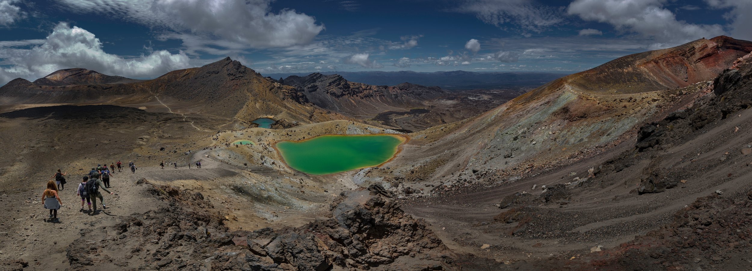
The Emerald Lakes of Mount Tongariro
The Emerald Lakes, also known as known as Ngarotopounamu (greenstone-hued lakes), stand out amongst the barren rock landscape of Mount Tongariro. Their striking vivid colours, due to dissolved mineral matter that has been washed down from the neighbouring thermal areas, are simply spectacular.
From here, it is a relatively short walk and climb to the Blue Lake.

The Blue Lake of Mount Tongariro
The Blue Lake (Te Wai-whakaata-o-te-Rangihiroa that translates as Rangihiroa's mirror), a cold acidic lake that is yet another product of volcanic activity in the Tongariro National Park.

Tongariro Alpine Crossing
Looking back from the Blue Lake to the Red Crater and the steady trail of people following behind us, the Tongariro Alpine Crossing really was a fantastic walk, albeit tiring.
Lessons learned for next time:
• Be fitter
• Bring more drinking water (I got dehydrated on the last hour back to the car park)
• Perhaps walk it a bit earlier in the year when there is a bit more snow around
• Take more unique photos 😊
Gallery

Click on one of the images above to view in the lightbox.
More visual stories


This visual journey follows Northland’s Twin Coast Discovery Highway, taking you through the Kauri Coast to the Far North, before returning via the Bay of Islands to Whangārei. Travelling in our motorhome, we dedicated two weeks to thoroughly revisit familiar spots and uncover new ones.