
Tama Lakes Walk

In September 2020 we hiked the Tama Lakes Walk that took us between two of Tongariro National Park’s active volcanoes, Ruapehu and Ngauruhoe to the Tama Lakes. An easier and beautiful alternative to the Tongariro Alpine Crossing.
In the first week of September 2020, Monique and I drove via the Napier-Taihape Road to the Tongariro National Park and Whakapapa village for a mid-week break. Covid-19 was still making its impact felt, so it was good to be away from home for a few days.
The first morning, I got up at 6am to take a traditional photo of the Chateau Tongariro hotel at sunrise with Mount Ruapehu in background. It was -1 degree Celsius and the grass was crunchy due to the frost, but the small amount of rain and snow that had fallen the evening prior had left no other evidence. The sky above the mountain was blue and cloudless, and I decided to combine the lights of the Chateau with the first sunlight on the peak to add some interest.

Chateau Tongariro Hotel Sunrise
A traditional photo of the Chateau Tongariro hotel at sunrise with Mount Ruapehu in the background.
Although the skies were blue above Mount Ruapehu, Mount Ngauruhoe was mostly covered in cloud and didn’t show itself for a good sunrise photo.
After a filling, cooked breakfast at the heritage Chateau Tongariro hotel, we decided to go for a day-walk to the Tama Lakes as a beautiful and less-crowded alternative to the Tongariro Crossing. The 17 km return track starts at Whakapapa village, winding through beech forest to the impressive Taranaki Falls. From there you can either return to the village or continue the well-maintained track to the lakes, which we did. The track to the Lower Tama Lake is easy to walk with the occasional stream to hop over. However, it is continuously climbing up small ridges and down into gulleys between two of Tongariro National Park’s active volcanoes; Ruapehu and Ngauruhoe.


The clouds gradually disappeared and were replaced by a blue sky with occasional clouds passing by, while the temperature increased to about 7 degrees Celsius. The plateau views opened up and the fields of tussock and alpine shrubs with patches of snow and icy streams were stunning.

Tongariro National Park Volcanic Landforms
The Tama Lake walk towards Mount Ngauruhoe reveals the alpine terrain shaped by a multitude of volcanic eruptions that started about 275,000 years ago.
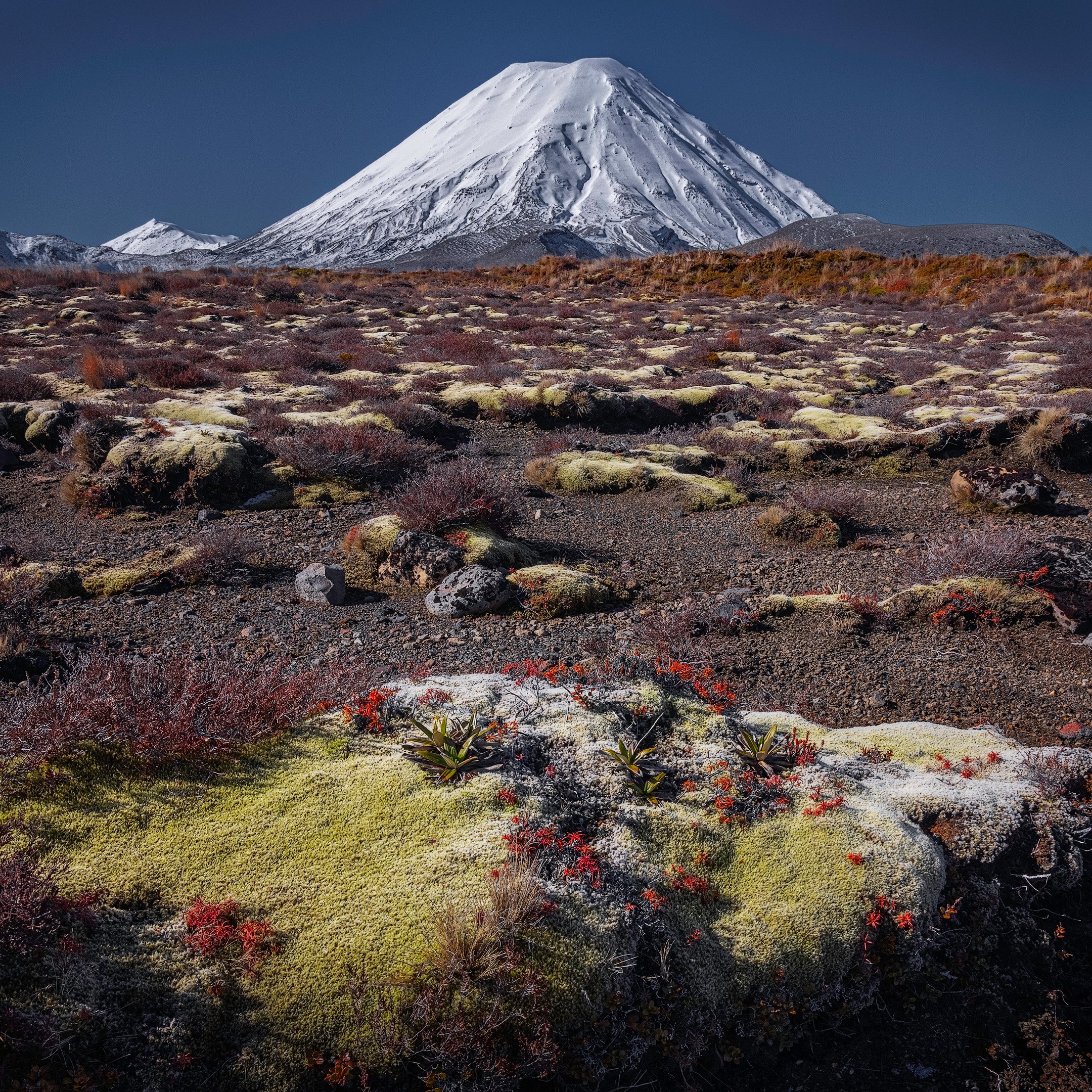
Alpine Flora and Mount Ngauruhoe
The alpine terrain surrounding the volcanoes of the central plateau is home to some beautiful and sturdy plants able to survive the harsh climate and volcanic soil.
We found some shelter from the cold wind and had a bite to eat while overlooking the Lower Tama Lake, talking to a few fellow day trippers, and watching people on top of the ridge. Monique started to walk back, while I continued the climb to the top lake.

Walking up the Tama Saddle toward the Upper Tama Lake
If you look closely, you can see people walking on the Tama Saddle on the right.

Lower Tama Lake and Mount Ruapehu
The Lower Tama Lake is a large, blue lake nestled into an explosion crater, steep sided and almost perfectly round. It’s located at 1,240 metres and the sandy flats at its mouth are criss-crossed by a snaking river bringing in eroded ash and other volcanic debris from the surrounding area.
From the Lower Tama Lake to the Upper Tama Lake, you follow the ridge line and climb up a scree slope, gaining 200m altitude. From here the track is steep, not formed and is made of loose and uneven scree that is much more challenging. It also very exposed to the weather and the temperature dropped significantly as the cold wind was blowing hard, so time to zip up and put on gloves.


While climbing towards the top, make sure you stop occasionally to catch a breath and look behind you, because the panoramic views of the lower lake with Ruapehu in the background get better as you climb up.
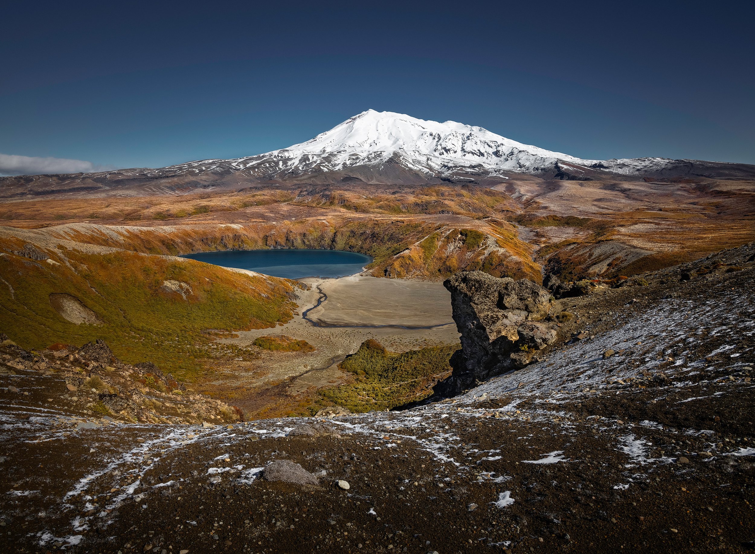
Upper Tama Lake
This shot of the Upper Tama Lake and the conical peak of Mount Ngauruhoe is one of the rewarding views at the turning point of the Tama Lakes Walk in the Tongariro National Park. The climb up the scree slope to this view can be quite challenging due to its steepness and exposure to the freezing wind. However, the 360-degree view from the ridgeline is definitely worth it.
The Upper Tama Lake occupies explosion craters that were active about 10,000 years ago. It is confined by steep cliffs made up of lava flows that are between 180,000 and 250,000 years old. This 10-metre deep lake (as well as the 24-metre deep lower lake) has no surface outlets, but it’s possible that it feeds springs that form the source of the Waihohonu Stream.
The walk down was straightforward, and the view of Mount Taranaki, about 150 kilometres away to the west, was very clear. I caught up with Monique at the Taranaki Falls and the 1-hour walk from there back to Whakapapa Village seemed to take much longer than the way up due to sore feet and tired legs, but the idea of dinner and a nice glass of wine at the Chateau kept us going.
Gallery

Click on one of the images above to view in the lightbox.
More visual stories


This visual journey follows Northland’s Twin Coast Discovery Highway, taking you through the Kauri Coast to the Far North, before returning via the Bay of Islands to Whangārei. Travelling in our motorhome, we dedicated two weeks to thoroughly revisit familiar spots and uncover new ones.