
Southern Scenic Route: Part 2 - The Catlins
The Southern Scenic Route is a tourist highway in New Zealand that follows the state highways and links Queenstown, Fiordland to Dunedin via The Catlins.
The second part of our 20-day journey following the Southern Scenic Route from Dunedin to Queenstown covers our trip through The Catlins from Kaka Point to Waipapa Point.
You can find the stories covering parts 1 and 3 here:

The Catlins is a spectacular coastal area in the south-eastern corner of the South Island of New Zealand between Balclutha and Invercargill. It is a rugged, sparsely populated area (make sure you have sufficient supplies with you if you plan to stay a few days), and the rough coastal beauty shaped by the ocean and wind is stunning.
On day 8, we left the small fishing village of Taiere Mouth, about 40 km southwest of Dunedin behind and traveled along the windy Clutha river and Balclutha to Kaka Point on the northern edge of The Catlins. While driving from Kaka Point along the beautiful coastline towards Nugget Point, we spotted a few Sea Lions, but also a Leopard Seal relaxing on the beach. We walked around Nugget Point and the lighthouse in preparation for photography at sunset and sunrise.
After parking our campervan at the camping ground in Kapa Point, we intended to go to the local pub/restaurant for a meal, but the lack of gluten free options meant that we cooked Thai with frozen veges in the camper instead. After dinner, we went back to Roaring Bay at Nugget Point to view penguins at 7pm. We scouted the bay for penguins coming on shore from the lookout, but after an hour of bracing the weather (rain, wind, and cold), we returned to the camper to drive back to the campsite. The next day we bumped into a fellow traveler who said that a penguin had appeared 5 minutes after we left.
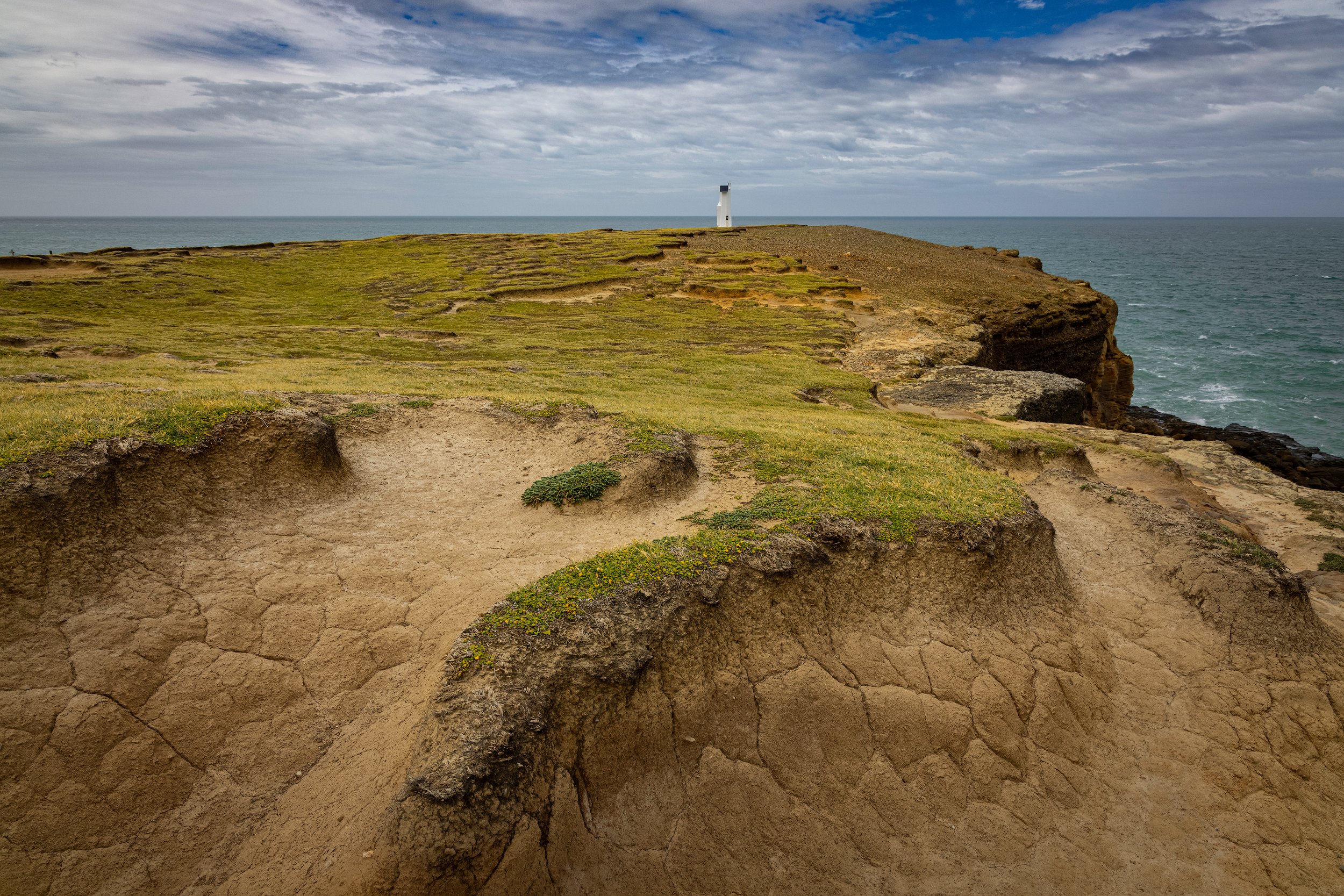
Nugget Point
The next morning, we got up at 4:55am to drive to Nugget Point and the famous lighthouse, which is an iconic landform on the Otago coast, located at the eastern side of the Catlins. The sky looked blue at our campsite, but there was a thick layer of cloud at the nuggets, so that wasn’t looking good. However, once the sun had risen high enough, above the clouds, the scene became compelling enough for a photograph. Monique had brought the binoculars and spotted a lot of wildlife, including nesting shags, black gulls, seal mums and pups, sea lions.
Nugget Point Lighthouse
Nugget Point is an iconic landform on the Otago coast, located at the eastern side of the Catlins.


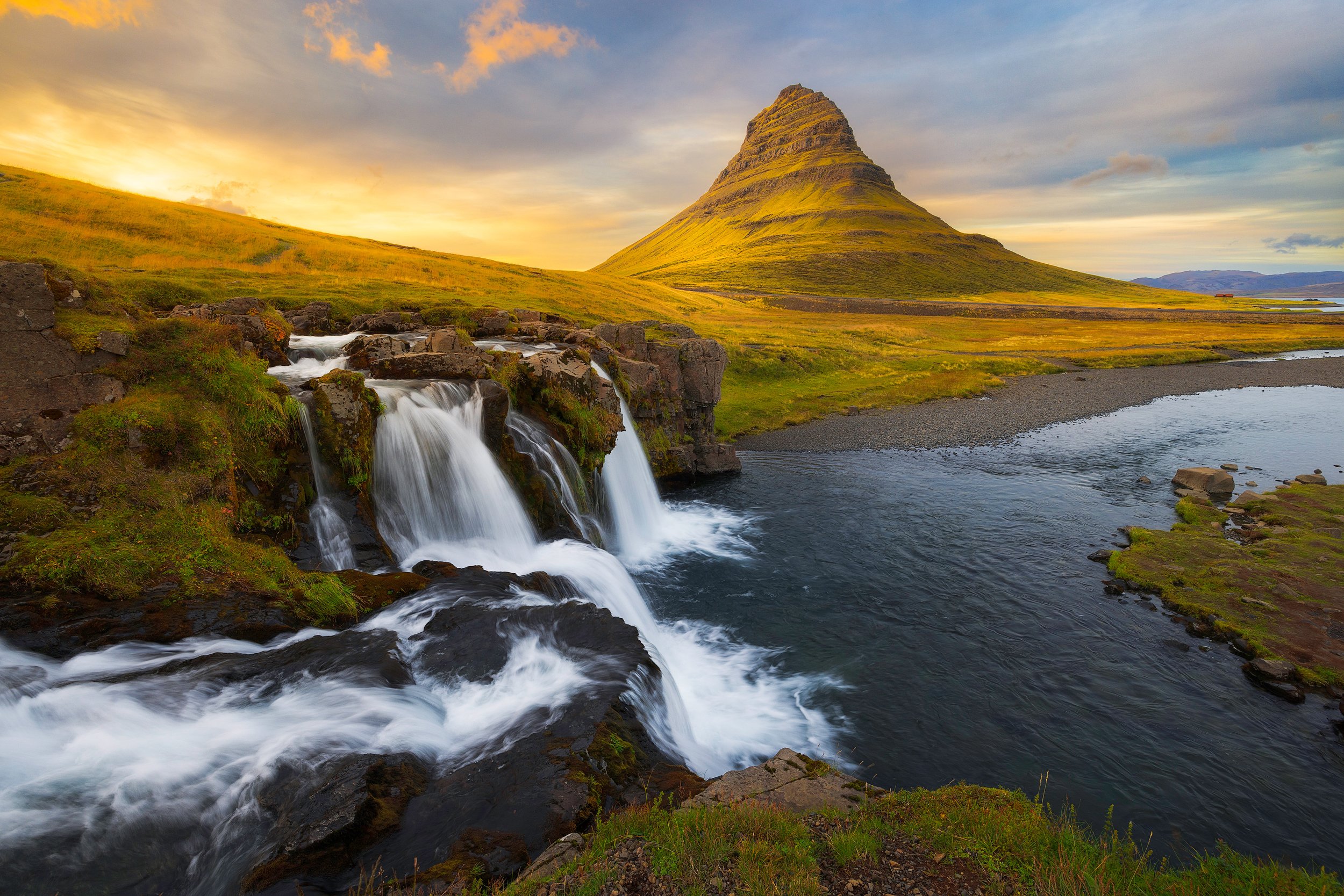
Spectacular Waterfalls in the Catlins
On day 9, we drove further along the coast and found a DOC camping site at Papatowai along the Tahakopa River. A good base for visiting a number of spectacular waterfalls, and most of them within easy walking distance from a carpark.
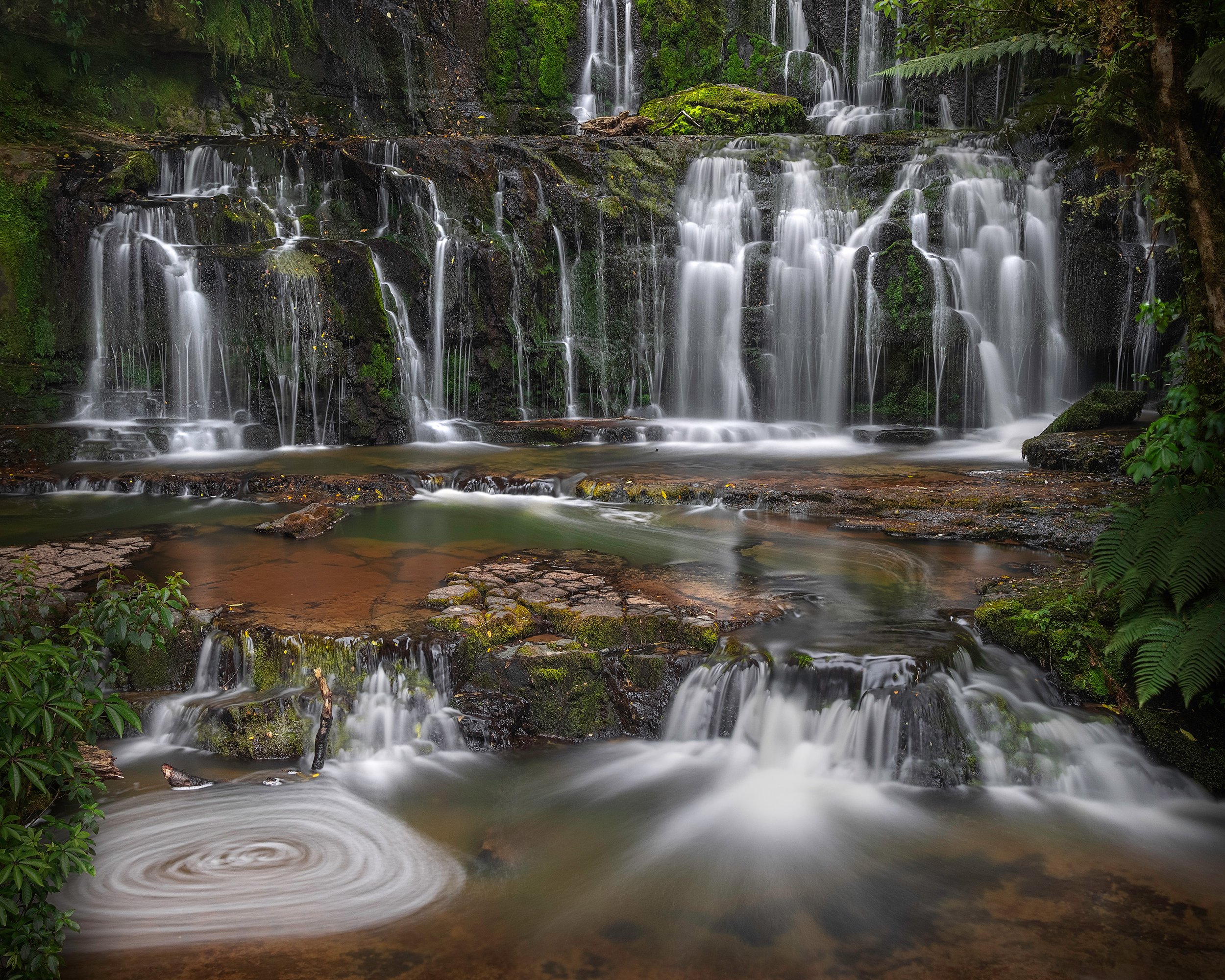
Purakaunui Falls, Catlins
The Purakaunui Falls are a cascading multi-tiered waterfall in the Catlins at the bottom of the South Island.
On the day I visited, the flow of the water created an interesting swirl at the bottom of the scene, adding something special to these iconic, frequently photographed waterfall.

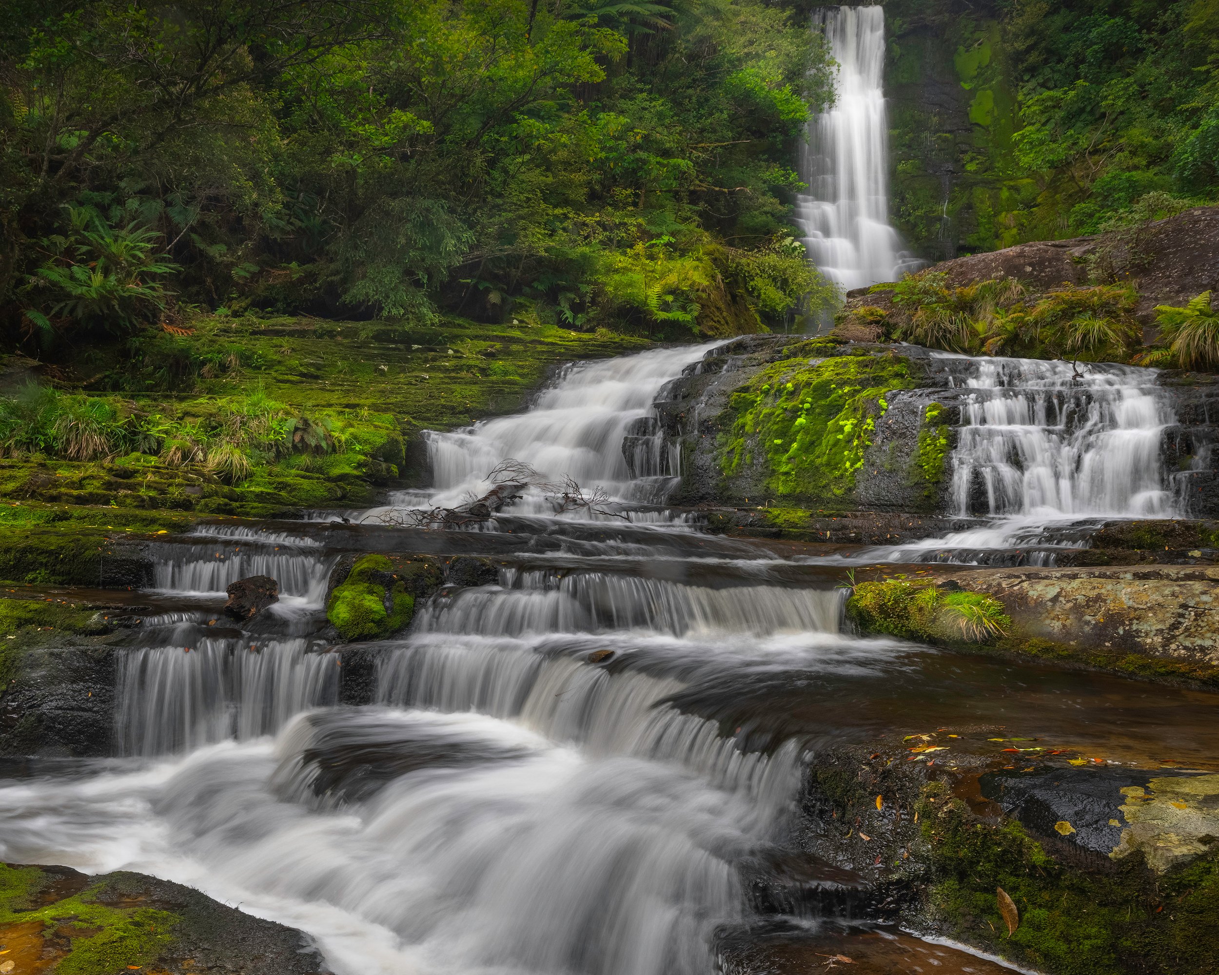

Matai Falls
Matai Falls is a small waterfall, beautifully nestled in the lush, bright green Catlins rainforest. It plunges 10 metres into a small clearing framed by moss-covered rocks and tree branches that I used to add foreground interest and depth to the composition.
Tahakopa River
Our DOC camping site was a very short walk to the Tahakopa River, which is 32 kilometres in length and flows southeastward through the Catlins into the Pacific Ocean close to the settlement of Papatowai.
Another early start as I got up 5:45 to shoot the sunrise along the Tahakopa River. The birds had been singing for an hour. Nice colours along the river with interesting rata trees that have horizontal trunks that then turn upwards. It was low tide, so unfortunately the trees were not in the water like they were the previous night when we arrived.
Not sure if that is a typical weather pattern in the Catlins, but it appears that the day usually starts with blue skies and some white clouds that then turn into larger, darker clouds as the day progresses, until evening. Around sunset this process seems to reverse as the large, grey skies start to disappear again, sometimes becoming quite colourful.

Tahakopa River Sunrise
The sun rises between fallen Rata trees along the mouth of the Tahakopa River in the Catlins.
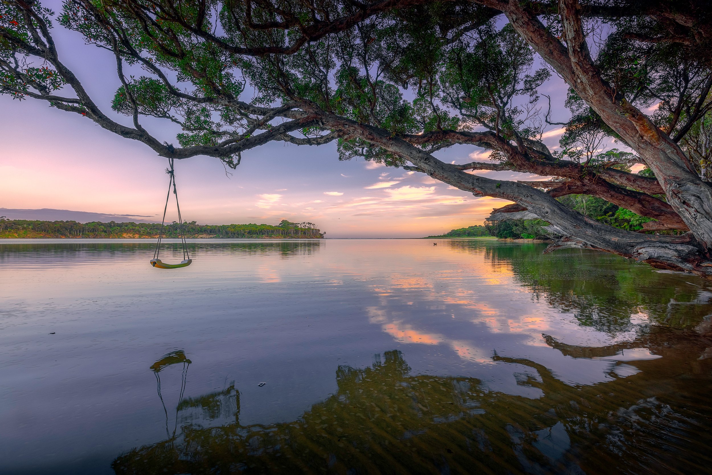
Swing above the Tahakopa River
After breakfast, we drove back to the Maclennan river reserve. I had seen some glimpses of the river the day before when we drove past it, and I instinctively felt there was a good shot there. It was difficult the find a park, so Monique ending up parking about 800m from where I ended up. It took a while to find a way to the river, but found a muddy road with a bridge not suitable for driving over anymore. Some beautiful reflections of native trees in the dark river water with nice puffy white clouds.
We carried on and found some other spots with tree reflections while driving west around Papatowai. We then came to Florence Hill Lookout that provided beautiful views over Tautuku Bay. Then a short drive to Lake Wilkie for more reflections.
Desperate for our caffeine fix, we stopped at the Whistling Frog for coffee with a very nice slice of chocolate with ice cream and cherries on top.


Light on Tahakopa Bay
Curio Bay
On the morning of day 11, we walked the old couch road walk along the Tahakopa River that brought us to the point where the river meets the sea. The river appeared to be a good place for a school excursion, as a group of school kids were kayaking with an instructor whose voice was carrying a very long distance.
We visited the Gypsy Café for coffee and were entertained by the creative, quirky and interactive inventions on display, before heading for Curio Bay. No food to be found anywhere. But after 2 days without power and cellphone coverage, we now had some. So time to charge the laptop and import photos, post some videos, and chat with the kids.
The wide coastal views of Porpoise Bay and Curio Bay, with endless waves, floating seaweed and Hector Dolphins, captivated us for hours. We saw three Hector Dolphins swimming in Porpoise Bay below us and walked to the petrified forest.

Curio Bay Sunset
The spectacular coastline of Curio Bay showcases the beauty of the Catlins coast.


Towards Invercargill
On day 12, we made our way through the west of the Catlins towards Invercargill. We stopped at Slope Point, the southernmost point of the South Island (and that's pretty much it). Apparently, when we were here in 2002 with my parents, my dad lost his glasses here, but the memory I have is of my parents looking down from the cliff being battered by the wind, while clinging on to a fence.
We had a walk around Waipapa lighthouse, where I got attacked by an oystercatcher protecting his/her nest.
The last stops were at Fortrose and Tokanui hoping for a store, but we ended up leaving again after putting some diesel in the tank.
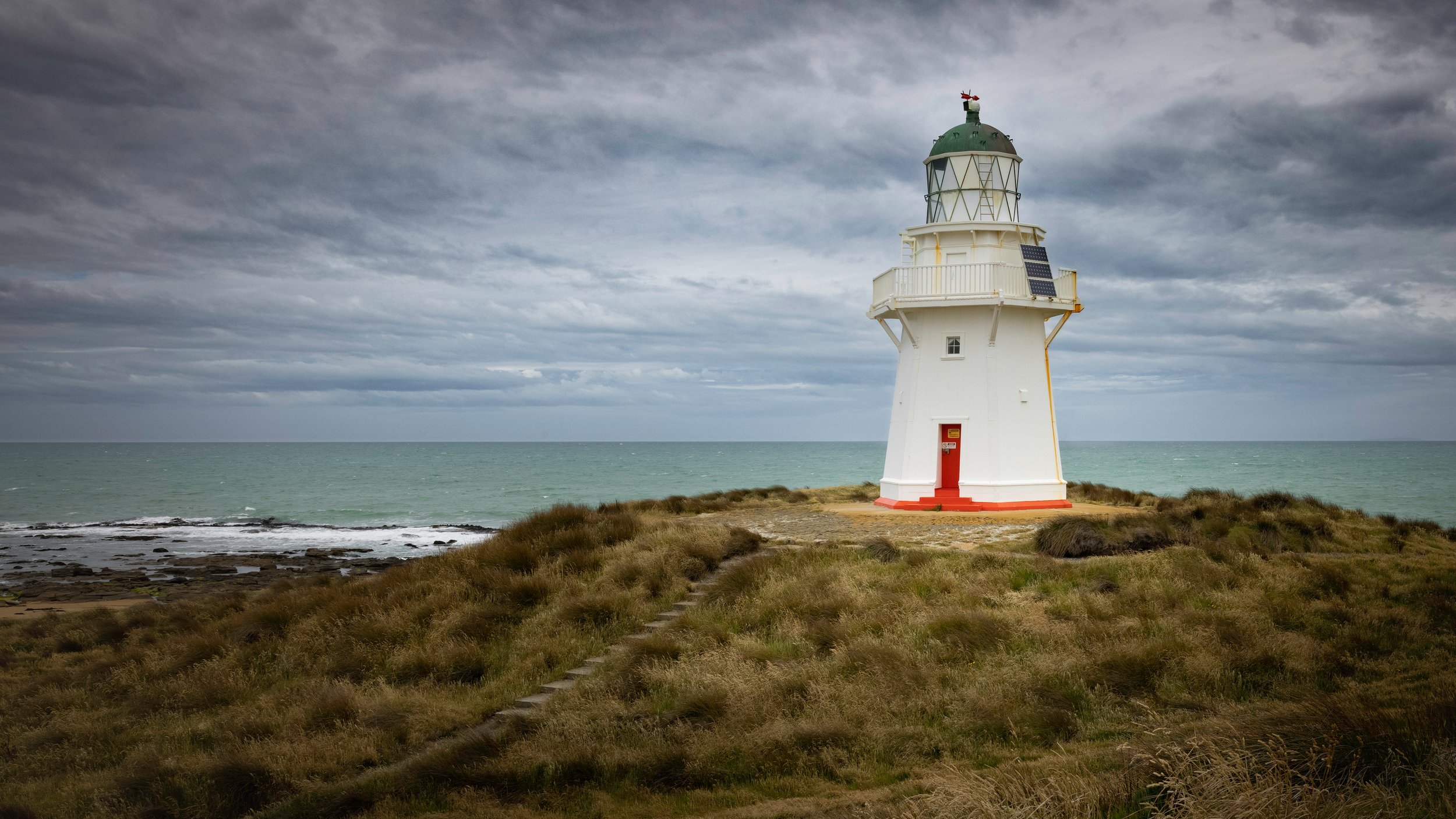
Waipapa Lighthouse

More articles about the Southern Scenic Route


Other visual stories


This is part 3 of a visual story about a 20-day journey following the Southern Scenic Route from Dunedin to Queenstown in early December 2020. This third part covers our trip through Fiordland, including Lake Hauroko, Manapouri, Doubtful Sound and Milford Sound, to Queenstown.