
Southern Scenic Route: Part 1 - Dunedin
The Southern Scenic Route is a tourist highway in New Zealand that follows the state highways and links Queenstown, Fiordland to Dunedin via The Catlins.
We drove the Southern Scenic Route from Dunedin to Queenstown in a campervan in early December 2020. It was a 20-day journey, and apart from experiencing our first holiday in a campervan (actually a self-contained motor home) and having a relaxing time, the goal was to exploit the lack of overseas tourists due to Covid-19 and take many great photos. The Route is approximately 610 kilometres long, so 20 days would give us plenty of days to experience the many natural attractions along the way.
We divided the tour up into three main parts:
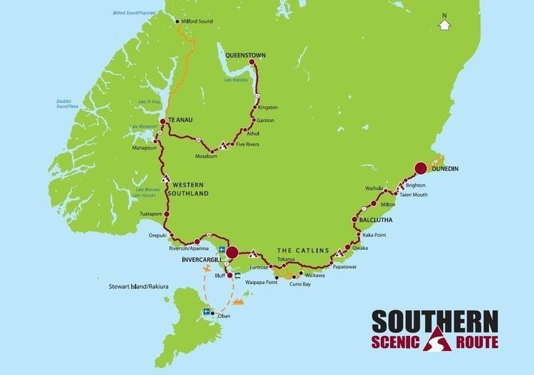
However, we started the tour in Christchurch where we picked up the campervan and drove just under 400 kilometres to Dunedin over 2 days with stops in Oamaru and Moeraki.
Bushy Beach Surf


Sometimes you just stand there and watch the endless landing of waves on the beach....
These photos were taken at Bushy Beach Scenic Reserve, a few minutes from Oamaru. This beach is home to Hoiho, yellow eyed penguins. However, the timing of our visit didn’t fit in with their daily schedule, so we just admired the coastal scenery and got mesmerised by the colours and patterns created by the surf.
Moeraki Boulders
Moeraki Boulders Dawn
The spherical boulders on the beach between the small coastal villages of Hampden and Moeraki.
Moeraki is famous for its boulders that are scattered on the nearby beach and is a must-stop destination when travelling along coastal Otago.
We got up at 4:55am to drive from our camping ground to the Moeraki Boulders to catch the sunrise. The tide was high-ish, and the pre-sunrise produced some nice colours. But it then sizzled out and we didn’t get to see the sun.
We were briefly joined by a seal swimming between the boulders to come ashore.
Blackhead Beach
Blackhead Beach is one of Dunedin's local beaches on the southern side of the city, popular with surfers. We overnight-ed here close to the quarry and had a great spot overlooking the beach and the waves that were backlit by the sun slowly setting behind them that produced a beautiful golden glow on the waves and the sand.

Blackhead Beach

Blackhead Gold
A strip of gold at Blackhead Beach close to Dunedin. Gotta catch that golden hour!!
Tunnel Beach Coastline
Tunnel Beach near Dunedin is part of a dramatic sandstone coastline with spectacular views. Determined to get the early light hitting the cliifs at sunrise, we got up at 4:55am to walk down the steep track.
The view didn't disappoint.

Tunnel Beach Sunrise
The dramatic sandstone coastline at Tunnel Beach near Dunedin.

Tunnel Beach
Descending the 72 steps down a historic pioneers' hand-carved tunnel (see the right hand side of the photo) leads to this secluded spot with sea-carved sandstone cliffs, rock arches and caves.
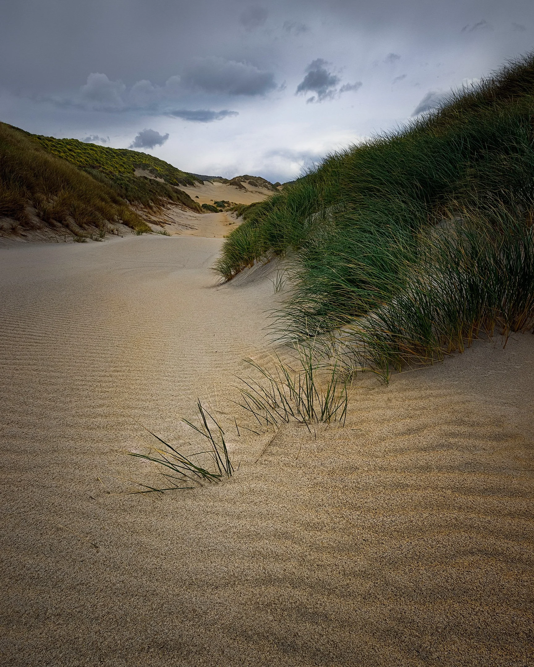
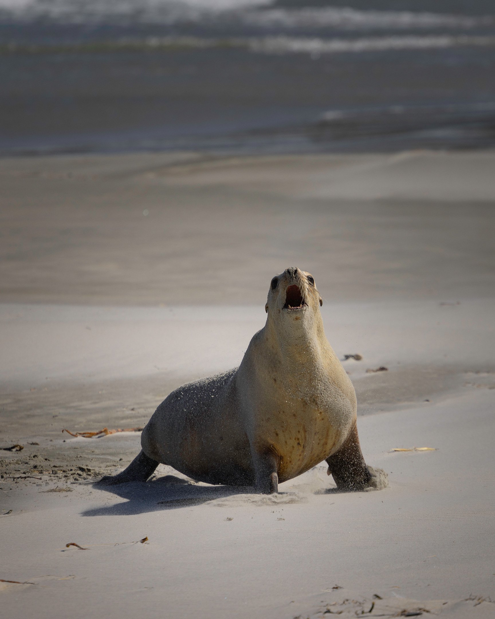
Sandfly Bay, Otago Peninsula
Sandfly Bay is located on the southern side of Otago Peninsula about 15km of central Dunedin. Sheltered by surrounding headlands and coastal rock formations, this bay provides magnificent views of large sand dunes that descend onto a wide beach. We saw several sea lions here that were resting on the beach and in the dunes.

Sandfly Bay, Otago Peninsula


More articles about the Southern Scenic Route


Other visual stories


This is part 3 of a visual story about a 20-day journey following the Southern Scenic Route from Dunedin to Queenstown in early December 2020. This third part covers our trip through Fiordland, including Lake Hauroko, Manapouri, Doubtful Sound and Milford Sound, to Queenstown.